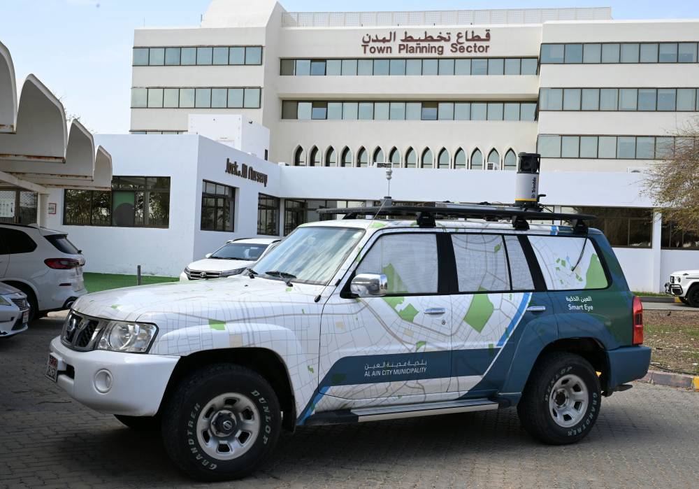
Information from the municipality in Al Ain indicated that the “Smart Al Ain” system has contributed, through the use of artificial intelligence, to improving the accuracy of spatial data with a precise aerial survey covering approximately 6000 square kilometers with high-resolution images ranging between 7 and 9 centimeters.
Furthermore, all areas of Al Ain, covering an area of 13,500 square kilometers, have been mapped using satellite images with a resolution of 30 centimeters. In addition, over 12,000 kilometers of main and secondary roads have been covered with panoramic images ranging in accuracy from 2 to 3 centimeters.
The implementation of the Smart Al Ain project is part of the plans of the Municipalities and Transport Department in Abu Dhabi to enhance and develop the quality of spatial information and increase its effectiveness. These results serve as vital sources for overseeing changes and managing renewal and improvement projects within the city’s strategic framework.
“Smart Al Ain” stands out for its ability to discover spatial dimensions through the system’s capability to derive location-related data.
Satellite images, aerial photography, and side view shots are used for purposes such as identifying building locations, light poles, trees, and traffic signs. These images also allow for data extraction by recognizing texts on directional signs in commercial areas and streets using optical character recognition technology.
Al Ain Municipality is leveraging the Smart Al Ain system to enhance efficiency and effectiveness in various municipal areas of work. This system enables the municipality to extract value from data collected from multiple sources to enhance its operations performance. This is achieved through utilizing artificial intelligence and machine learning services to improve the quality of spatial information, resulting in positive impacts on the quality of infrastructure projects and road networks studies in Al Ain.
The project effectively contributes to enhancing the services of the Municipalities and Transport Department and its affiliated entities, serving as a fundamental resource for various applications such as road resource management, monitoring operations, and map preparation. The system integrates spatial geographic data collection with high-quality images, allowing for a precise understanding of the studied areas, evaluation of current conditions, and recording asset information.
Engineer Mohammed Al Rashidi, Head of the Geographic Information Systems Department at Al Ain Municipality, stated to WAM Agency that “Smart Al Ain” is a project based on four key data collection resources, namely:
Aerial image capture, satellite imaging, geophysical aerial imaging, and 360-degree angular images. This falls within the municipality’s initiatives to enhance the effectiveness and quality of spatial information, contributing to acquiring high-quality and accurate location data. The project also helps expedite visitors’ procedures and enhances decision-making effectiveness in approving future projects.
The success of the Smart Vision system application in the Maraya – Khubaisi data collection mission has been highlighted, demonstrating the system’s efficiency in extracting accurate geospatial results, with analysis precision exceeding 90%. This reflects the system’s strength in providing highly specific information in an easily accessible format, aiding in smooth data analysis and efficient decision-making.
In the same context, the municipality has commenced the geographic survey task covering all residential, industrial, commercial, and agricultural areas in Al Ain, resulting in a coverage of approximately 9122 linear kilometers by the end of 2023. Survey activities are ongoing to complete the remaining sections of the city.
The surveying process in this context captures panoramic images utilizing the top-quality image capture capabilities of the MX7 device, which enables rapid integrated photography and data collection, in addition to spatial geographic analysis capabilities, allowing for efficient updating of the base map.


